Chaco Canyon is also the site of a remarkable solstice marker, located atop Fajada Butte in the main canyon. The site was discovered in the late 1970's by an artist named Anna Sofaer, who was studying rock art in the region. It was an extremely fortuitous discovery, for a number of reasons. The marker resembles nothing more than a group of large slabs of rough stone leaning against the side of a cliff high up on the butte. On the wall of the cliff behind the stones two spiral designs had been carved. Nothing about the site suggests it was particularly important or noteworthy, yet Ms Sofaer discovered that at midday of the winter soltice, light shining through the stone slabs casts a wedge-shaped beam upon the center of the larger spiral, which slowly descends through the spiral and disappears. For this reason, the marker is known as "The Sun Dagger".
It was an incredibly exciting discovery. Later observations confirmed that the marker also marks the summer solstice and both equinoxes. Finally, experimentation has shown that the 19 year lunar cycle was also marked. This was an altogether remarkable achievement, but the story isn't finished there. In the early 90's the stone slabs shifted their position. Had Ms Sofaer not made her discovery when she had, chances are very good that the existence of the Sun Dagger would never have been known to us. Efforts to restore the marker are now underway. Because of its fragility, the site is not open to the public, but a video on the marker can be viewed at the visitor's center.
|
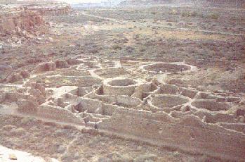
Chetro Ketl - a view of the town from the Pueblo Alto trail on the north mesa. |
|---|---|
|
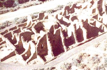
Kin Kletso - another town viewed from the Pueblo Alto trail. The circular structures in this and the previous images are called kivas. The Hopi, Zuni, and Rio Grande Pueblo peoples use similar structures today as centers of ceremony, worship, and social interaction. |
|
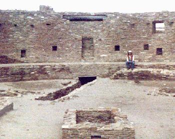
The Great Kiva - In Chaco Canyon, most of the towns are located along the north side of Chaco Wash, and their kivas are an integral part of their structure. On the south side of Chaco Wash stands Casa Rinconada, also called the Great Kiva. This kiva is more than twice the size of any other in the canyon. It stands among a small set of ruins that were crudely built as compared with the Great Kiva and the pueblos on the north bank. It is speculated that Casa Rinconada was a ceremonial center for all of the communities in the canyon. |
|
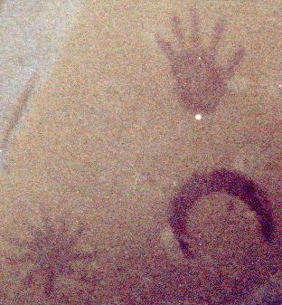
The Supernova Pictograph - In AD 1054 a new star appeared in the constellation Taurus, so bright it was visible even by day. Today we know this object as the Crab Nebula, the remnants of a supernova of a massive star. The Chinese recorded this event at the time of its appearance, and many archaeologists believe that the Anasazi did so as well, with this set of pictographs located along the trail to Penasco Blanco ruin. The crescent shape accurately represents the phase of the moon at the time of the explosion, while the star shape is thought to represent the supernova itself. The handprint seems to be in the nature of a signature. |
Chaco Canyon is located in northwestern New Mexico, roughly 50 miles south of Farmington. It can be reached from state route 44 from the north, and from interstate route 40 from the south. Either way, the last 20 to 25 miles are driven over graded dirt roads.
